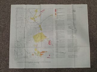
Landslide and Associated Deposits Map of the Sugar House Quadrangle, Salt Lake County, Utah (35″x29″) (1972) ~ by Richard Van Horn

$16.00

Landslide and Associated Deposits Map of the Sugar House Quadrangle, Salt Lake County, Utah

(35″x29″)

By Richard Van Horn

Published: 1972

Good condition map kept within a manilla envelope.  The envelope has some scuffing, fading, writing in pencil, and eraser marks.  The map has no visible wear.

v111 1074
1 in stock

SKU: v111 1074 CRS B4 Categories: , , Tags: , ,

Description

Landslide and Associated Deposits Map of the Sugar House Quadrangle, Salt Lake County, Utah

(35″x29″)

By Richard Van Horn

Published: 1972

Good condition map kept within a manilla envelope.  The envelope has some scuffing, fading, writing in pencil, and eraser marks.  The map has no visible wear.

v111 1074