

1876 Maps of Warrick and Spencer Counties in Indiana — 17″ X 14″
$20.00
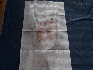
This “Map of Warrick County” is 17 inches tall and 14 inches wide. It has another Indiana map on the other side, which is “Map of Spencer County.”
While this map is pinkish, the Spencer county map is green.
One corners is a bit torn off and missing, as you can see in the photo. Some holes along one edge so you can tell it was originally in an old atlas of Indiana published in 1876. The book was falling apart and was missing many pages, but some maps were able to be salvaged.
1 in stock
Related products
-
Geologic Map of the Southwest Quarter of the Gunsight Butte Quadrangle: Map MF-206 – Fred Petersen
$25.00 Add to cart -
Map Showing Locations of Mines & Prospects in the Dillon Quadrangle (I-1803-C) Idaho & Montana
$10.00 Add to cart -
Geologic Map of the Three Peaks Quadrangle, Iron County, Utah (Map GQ-1297)
$10.00 Add to cart -
Map of Norfolk, Virginia and Miscellaneous Information for Visitors and New Residents (Map)
$12.50 Add to cart -

Geologic Map of the Cedar City Quadrangle, Iron County, Utah (Map GQ-1120)
$10.00 Add to cart -
2 Geologic Maps of Uintah County, Utah (North Half, South Half) ~ by G. E. and B. R. Untermann, and D. M. Kinney
$15.00 Add to cart -
Geology of Min Hill and the Underground Workings, Mahd ADH Dhahab Mine, Kingdom of Saudi Arabia: Technical Record USGS-T-03-2 (IR 592) (1984) ~ by Lowell S. Hilpert, Ralph J. Roberts, and Gavin A. Dirom
$75.00 Add to cart -
Geologic Map of the Dugway Proving Ground SW Quadrangle, Utah (Map GQ-992)
$9.99 Add to cart -
Geologic Map of the Heber Quadrangle, Utah (Map GQ-864)
$7.50 Add to cart -
Geology of the Southern Wasatch Mountains and Vicinity, Utah Map (1962)~ by Lehi F. Hintze
$12.50 Add to cart